Concepts
Envisions' DataMapper is based on the following concepts:
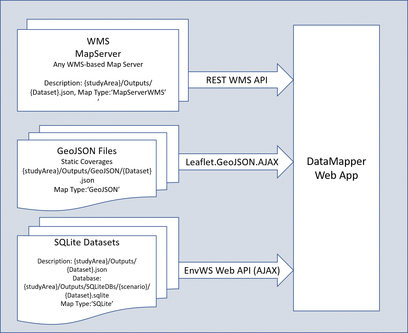
Basic Building Blocks of a DataMapper WebApp
Map Types and Sources
The DataMapper allows specification of map layer from multiple sources, as specified in the table below:
| Map Type | Description | Year Types | Interactive | Example | Notes |
|---|
| MapServerWMS | MapServer WMS server | SingleYear | Yes | http://envweb.bee.oregonstate.edu/MapServer/mapserv.exe?map=D:/MapServer/apps/deschutes/maps/{scenario}/IDU/{year}_{run}.map | |
| SQLite | GeoJSON file | n/a | No | /Topic/Deschutes/Outputs/Urban_Growth_Boundary.json | Static maps overlayed on IDUs |
| GeoJSON | Server-hosted GeoJSON file | n/a | No | /Topic/Deschutes/Outputs/Urban_Growth_Boundary.json | Static maps overlayed on IDUs |
Map/Data Sources
DataMapper application can get map layers throught the mechanisms describe in the table above. These sources are described in more detail below.
MapServer WMS
IDU Layers, and similarly prepared layers, can be accessed using a Web Map Service (WMS) interface.
For example, specifying the in the {datasetName}Info.json: let src = "http://envweb.bee.oregonstate.edu/MapServer/mapserv.exe?map=D:/MapServer/apps/deschutes/maps/" + scenario + "/IDU/" + year + ".map";
SQLite Databases (Datasets)
The DataMapper uses one or more SQLite databases (termed "datasets") that store spatial and non-spatial data, including temporal
changes and associated geomeries. These
datasets are described below. Datasets are stored as SQLite databases located on the server at:
{studyArea}/Outputs/SQLiteDBs/{scenario}/{datasetName}.sqlite. They are generated by a Python script...
All Envision application will have, at a minimum, an IDU dataset for each scenario. This dataset contains three table types:
- Tables containing reduced IDU datatables (without shape/geometry data), one for each year in the simulation, containing only
the fields specified as being available in the Datamapper application.
- A table named "geometry" containing the geometery associated with the IDU coverage
- A table named "deltaArray" containing the reduced Delta Array for simulation
Conformant SQLite tables can be accessed through the Envision Web Services API. To be available to the
WebAPI interfaces, the application needs to generate an SQLite database located at
{studyArea}/Outputs/SQLiteDBs/{scenario}/{datasetName].sqlite.
This allows additional layers beyond the IDU layers indicated to be automatically included in a DataMapper application.
Conformant datasets have the following qualities:
- Year Type='SingleYear' => should represent the dataset coverage for a given (single) year (no geometry); scenario, year, run encoded in table name
- Year Type='MultiYear' => must contain the fields "YEAR" and "SCENARIO"
| Database | Description | >
|---|
| IDU | MapServer WMS server | SingleYear | Yes | http://envweb.bee.oregonstate.edu/MapServer/mapserv.exe?map=D:/MapServer/apps/deschutes/maps/{scenario}/IDU/{year}_{run}.map | |
generating a {DatasetName}Info.json file describing the dataset, located in the {studyArea}/Outputs/ folder
generating a {DatasetName}Info.json file describing the dataset, located in the {studyArea}/Outputs/ folder